


Name: Kevin Kiprotich
Profile: Full Stack Software Developer || GIS & RS Analyst
Address: Nairobi, Kenya
Email: kevinkiprotich0089@gmail.com
Phone: +254746620591 || +254714241256
I am a versatile Full Stack GIS Software Developer with a passion for crafting innovative geospatial solutions. With expertise in a wide range of technologies, including React, JavaScript, Google Earth Engine, Django, Python, web development, Flutter mobile development, and data science and machine learning, I bring a unique blend of skills to every project I undertake.
Whether it's creating captivating web applications, harnessing the power of geospatial data, or building cutting-edge mobile experiences, I thrive on turning ideas into reality. My commitment to pushing the boundaries of what's possible in the world of GIS and software development drives me to deliver exceptional results for every client and project. Let's collaborate to bring your geospatial vision to life
Mobile App Development
By leveraging the latest mobile technologies and best practices, I build apps that are not only highly functional but also aesthetically appealing. My focus is on creating user-centric solutions that solve real-world problems and keep users engaged, whether for Android or iOS platforms.
Web Development
I build dynamic, responsive websites and web applications that prioritize performance, usability, and scalability. Using modern web technologies, I create user-friendly solutions that perform seamlessly across devices, delivering an optimal browsing experience for users.
Internet of Things (IoT)
I develop IoT solutions that connect physical devices to the digital world, enabling real-time data collection and automation. By integrating sensors and actuators, I design systems that improve operational efficiency and enable smarter decision-making through data-driven insights.
GIS and Remote Sensing
I analyze and visualize geospatial data to provide insights into environmental and urban trends. My work supports informed decision-making by leveraging satellite imagery and spatial data to address issues in agriculture, land management, environmental conservation, urban planning and many more.
Data Science & ML
I apply advanced data analysis and machine learning techniques to extract actionable insights from complex datasets. My goal is to build models that optimize processes, predict trends, and provide data-driven solutions to real-world challenges.
QGIS Plugin Development
I develop custom QGIS plugins that extend the platform’s capabilities, enabling users to perform complex geospatial analyses with ease. My focus is on creating intuitive tools that streamline workflows and improve the efficiency of spatial data processing and visualization.
HTML
CSS
Javascript
Python
R
React
Flutter & Dart


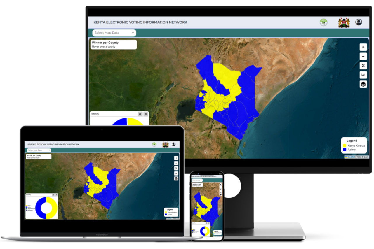
Kenya Electronic Voting Information System
The dashboard is designed as a user-friendly web-based interface that allows users to access and interact with data related to a general elections. It provides an intuitive and visually engaging experience, primarily centered around geographical data and visual representations of election results. Users can explore maps, charts, and graphs to gain insights into the election outcomes, making it easy to understand and interpret the data
Link
Geofenced Smart Speed Governor Technology
This is an innovative solution that enables location-based speed control for vehicles. It uses geofencing technology to dynamically adjust speed limits based on predefined geographical zones to ensure compliance with area-specific speed regulations, enhancing road safety and minimizing the risk of speeding-related incidents. Through real-time monitoring and automatic speed adjustments, this technology provides an efficient approach to smart vehicle management.
Link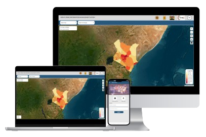
Crime Information Management System
The Crime Information Management System is a powerful tool designed for visualizing and reporting crime data across Kenya. This platform provides law enforcement and the public with a user-friendly interface to access real-time crime statistics and trends. Users can explore interactive maps, making it easy to understand crime patterns geographically. With detailed reporting capabilities, the system supports data-driven decision-making, promoting a transparent approach to crime information management in Kenya.
Link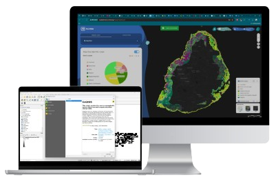
Coastal Geomorphology and Shoreline Change Analysis (CoGeoS)
CoGeoS is an integrated monitoring system focused on safeguarding coastal ecosystems by tracking coastal erosion, benthic habitats, and coastal land use. Through its powerful tools—including a QGIS plugin, and an online geoportal, it provides real-time data and visualizations to support sustainable coastal management and the preservation of vital coastal resources.
Link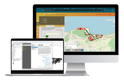
Monitoring Intergrated Services for Land Degradation (MISLAND)
This is a versatile platform that includes a QGIS plugin, a mobile app, and a geoportal. Together, these tools provide accessible, real-time monitoring of land degradation across African landscapes. With capabilities for analyzing forest cover, vegetation health, coastal erosion, and more, MISLAND empowers decision-makers with actionable insights to promote sustainable land management and achieve Land Degradation Neutrality.
Link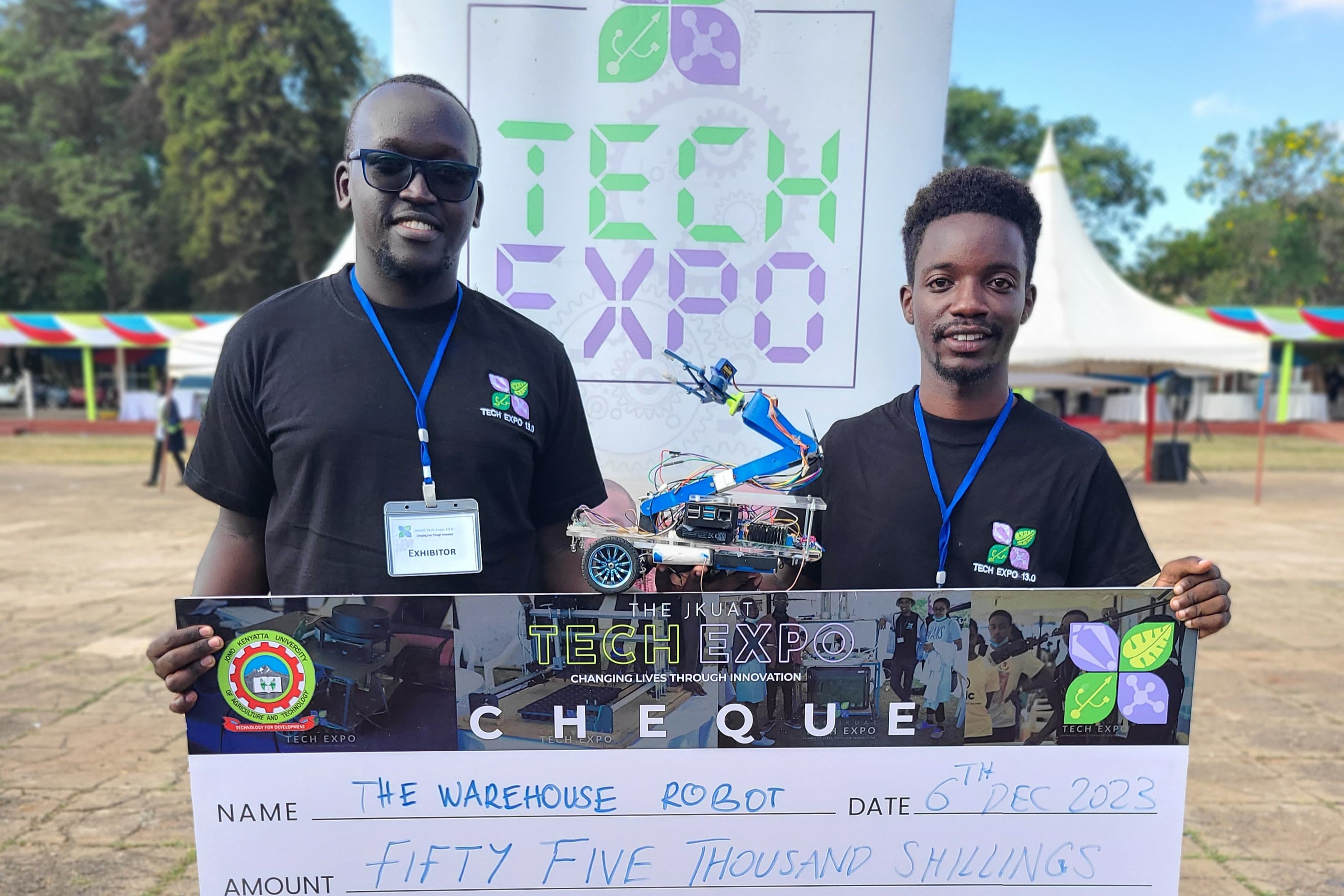
Warehouse Robot
The warehouse robot is an advanced solution for efficient, real-time inventory management and storage operations. Leveraging precise navigation and automation technology, it optimizes the handling, tracking, and storage of goods within warehouse facilities. The robot autonomously updates inventory records and organizes goods based on predefined storage zones, ensuring accuracy and reducing the need for manual input. This significantly enhances workflow efficiency and accuracy, minimizing human error.
Link
Nairobi, Kenya
+254746620591 || +254714241256
kevinkiprotich0089@gmail.com
Kevin-Kiprotich